Garmin® unveils the G1000H® NXi Integrated Flight Deck Next-generation, all-glass solution for helicopters
Garmin International, Inc. a unit of Garmin Ltd. (NASDAQ: GRMN), today
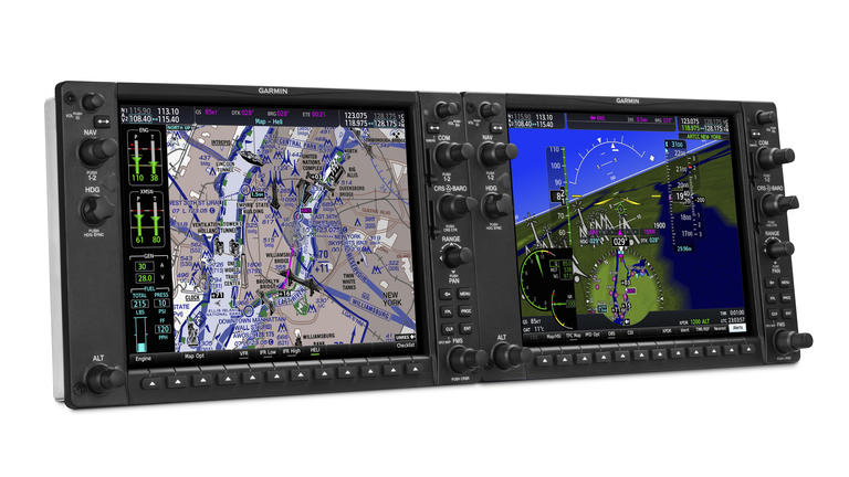
announced the G1000H NXi, the next-generation, all-glass integrated
flight deck designed specifically for the FAR Part 27 VFR helicopter
market. The G1000H NXi offers a number of new and enhanced features
tailored to helicopter pilots, including Database Concierge, U.S.
helicopter-specific charts, helicopter terrain awareness warning system
(HTAWS) and WireAware™ wire-strike avoidance technology featured in
rich, 3-D helicopter synthetic vision technology (HSVT). It’s also
equipped with advanced ADS-B-in display, HSI map and visual approach
capability. Powered by faster, brighter, smoother high-resolution
displays, the next-generation G1000H NXi offers an extremely
pilot-responsive and advanced integrated flight deck that provides
pilots with critical decision-making information – flight
instrumentation, navigation, communication, weather, terrain, traffic,
identification, and diagnostics and maintenance computer – in a
consolidated, easy to understand format.
“The G1000H NXi takes the industry’s most trusted glass flight deck
platform to a new, unprecedented level of performance and capability,”
said Carl Wolf, Garmin vice president of aviation sales and marketing.
“We’re humbled by the popularity and adoption of the G1000 NXi, and
building on its success, we’re excited to introduce the G1000H NXi that
brings this innovative technology and superior feature set to the
helicopter market.”
The physical architecture of the G1000H NXi is similar to the
earlier-generation G1000H, but thanks to the system’s new dual-core
processors, its speed, power and capacity for future growth is
dramatically boosted. The G1000H NXi features a pilot-selectable
split-screen capability that allows for two or more separate page views
to be displayed simultaneously, so pilots can access more valuable
decision-making information at a glance without having to flip through
multiple pages in sequence. To support night operations, the G1000H NXi
is also compatible with night vision goggles (NVG).
The G1000H NXi boasts many new and enhanced operational features and
optional capabilities, including:
-
WireAware wire-strike avoidance technology that graphically
overlays the most comprehensive powerline information right on the
moving map page for the U.S. as well as some locations in both Canada
and Mexico. -
HTAWS with five-color display shading and audible voice callout
alerts for powerlines as well as potential terrain and obstacle
hazards along the flight path. -
Helicopter Route Charts are offered throughout eight U.S.
metropolitan areas, including the Gulf of Mexico, and provide
three-color charts that depict helicopter airways and routes,
heliports with associated frequency and lighting capabilities, NAVAID
information, obstructions and more. For a faster, more intuitive way
of judging target trajectories and closure rates in relation to the
flight path, ADS-B-enabled TargetTrend™ is available and
especially ideal for picking out the real threats when in dense
traffic environments. -
ADS-B-enabled TerminalTraffic™ for helicopters recognizes the
unique operational requirements of these airframes within the airport
environment and is optimized to keep “nuisance” alerts to a minimum –
while maintaining pilot awareness of potential traffic conflicts.
Alerts from nearby fixed-wing aircraft are minimized and abbreviated
when the helicopter is hovering or performing other maneuvers unique
to helicopter operations. -
Connext® cockpit connectivity with added Database Concierge and
flight plan transferring with a compatible tablet or smartphone that
automatically uploads and syncs databases. -
HSI mapping that puts a multifunction display (MFD) like
perspective map view within the primary flight display (PFD) to help
pilots focus on instrumentation scan, enabling them to better
visualize nearby flight and enroute navigation features, especially
when things get busy in the cockpit. -
Visual approach generates a three-degree vertical path from the
threshold of the runway down to pilot-selectable minimums. -
HSVT displays an “out-of-the-window” view of the surroundings,
regardless of the weather conditions. This synthetic vision seamlessly
blends information about the helicopter’s position with topographic
databases to create and display real-time 3-D images. Land, water and
sky are clearly differentiated with shading and textures that are
similar to the topographical colors found on the MFD moving map. HSVT
alerts pilots of potential ground hazards by displaying terrain,
obstacles and powerlines which pose a threat to the aircraft.
Additional features and capabilities available with the G1000H NXi
include: SiriusXM high-resolution animated weather radar imagery, verbal
ATC-like TAS/TCAS spoken traffic alerts, Telligence™ voice control,
global voice/text, ADS-B out and much more. The system is also capable
of displaying onboard weather radar, radar altimeter, engine information
and video input from compatible camera sources.
The G1000H NXi is supported by Garmin’s award-winning aviation product
support team, which provides 24/7 worldwide technical and warranty
support. For additional information about the G1000H NXi or Garmin’s
complete line of helicopter products, visit www.garmin.com/helicopters.
Garmin’s aviation business segment is a leading provider of solutions to
OEM, aftermarket, military and government customers. Garmin’s portfolio
includes navigation, communication, flight control, hazard avoidance, an
expansive suite of ADS-B solutions and other products and services that
are known for innovation, reliability, and value. For more information
about Garmin’s full line of avionics, go to www.garmin.com/aviation.
For decades, Garmin has pioneered new GPS navigation and wireless
devices and applications that are designed for people who live an active
lifestyle. Garmin serves five primary business units, including
automotive, aviation, fitness, marine, and outdoor recreation. For more
information, visit Garmin’s virtual pressroom at garmin.com/newsroom,
contact the Media Relations department at 913-397-8200, or follow us at facebook.com/garmin,
twitter.com/garmin,
or youtube.com/garmin.
About Garmin
Garmin International Inc. is a subsidiary of Garmin Ltd. (Nasdaq: GRMN).
Garmin Ltd. is incorporated in Switzerland, and its principal
subsidiaries are located in the United States, Taiwan and the United
Kingdom. Garmin and G1000H are registered trademarks and WireAware,
TargetTrend and TerminalTraffic are trademarks of Garmin Ltd. or its
subsidiaries.
All other brands, product names, company names, trademarks and service
marks are the properties of their respective owners. All rights reserved.
Notice on Forward-Looking Statements
This release includes forward-looking statements regarding Garmin Ltd.
and its business. Such statements are based on management’s current
expectations. The forward-looking events and circumstances discussed in
this release may not occur and actual results could differ materially as
a result of known and unknown risk factors and uncertainties affecting
Garmin, including, but not limited to, the risk factors listed in the
Annual Report on Form 10-K for the year ended December 31, 2016, filed
by Garmin with the Securities and Exchange Commission (Commission file
number 0-31983). A copy of such Form 10-K is available at www.garmin.com/aboutGarmin/invRelations/finReports.html.
No forward-looking statement can be guaranteed. Forward-looking
statements speak only as of the date on which they are made and Garmin
undertakes no obligation to publicly update or revise any
forward-looking statement, whether as a result of new information,
future events, or otherwise.
Contacts
-
Images
